Mapping Global Methane Emissions from Space: Google Research Leverages Deep Learning for Climate Sustainability
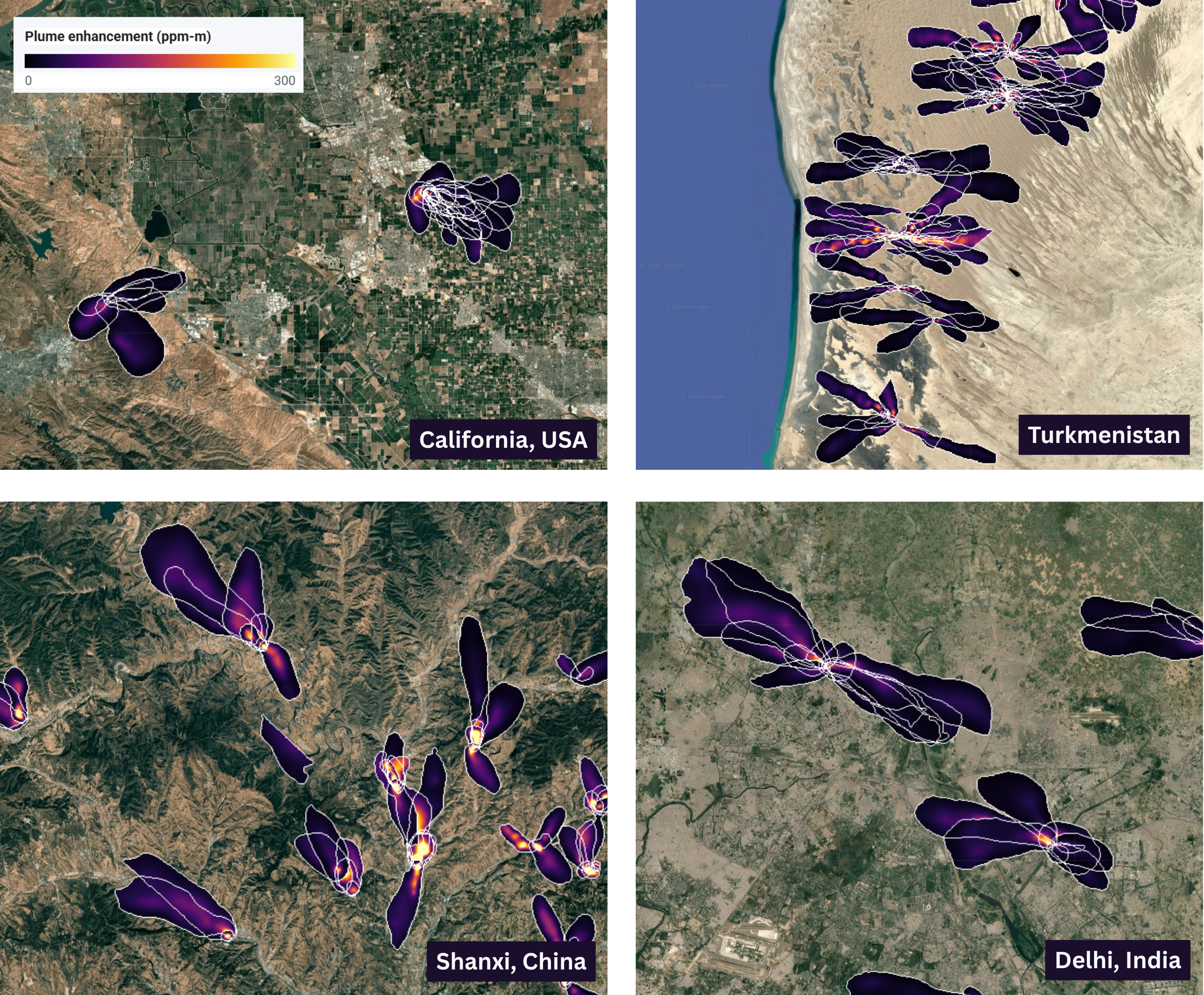
Google Research has unveiled a significant initiative focused on mapping global methane emissions using advanced deep learning and space-based technology. Categorized under Climate & Sustainability, this research highlights the intersection of artificial intelligence and environmental science. By utilizing satellite data, the project aims to provide a comprehensive and detailed view of methane sources across the planet. This approach addresses the critical need for accurate environmental monitoring to combat climate change. The integration of deep learning allows for the processing of complex spatial data, enabling the identification of emission patterns that are essential for global sustainability efforts. This announcement underscores the growing role of high-level AI research in addressing some of the world's most pressing ecological challenges.
Key Takeaways
- Deep Learning Integration: Google Research is utilizing advanced deep learning models to analyze and map methane emissions globally.
- Space-Based Monitoring: The initiative relies on data captured from space to ensure comprehensive coverage of the Earth's surface.
- Climate & Sustainability Focus: The project is a core part of Google's efforts to apply technology toward environmental preservation and sustainability.
- Global Mapping Capabilities: The use of AI enables the identification of methane sources on a scale and at a resolution previously difficult to achieve.
In-Depth Analysis
The Role of Deep Learning in Satellite Data Interpretation
The primary focus of the research published by Google Research is the application of deep learning to the complex task of mapping methane emissions from space. Methane, a significant contributor to the greenhouse effect, presents unique challenges for detection due to its invisible nature and the vast areas over which it can be dispersed. Traditional methods of monitoring often fall short in providing a real-time, global perspective. By employing deep learning, Google Research can process massive datasets generated by satellites, identifying specific signatures of methane plumes with high precision. This technological leap allows for the automation of data analysis, transforming raw satellite imagery into actionable environmental maps. The deep learning models are designed to recognize patterns and anomalies in atmospheric data, which is crucial for pinpointing the exact locations of methane leaks and natural emissions.
Advancing Climate & Sustainability Through Space Technology
Positioned within the realm of Climate & Sustainability, this initiative represents a strategic move to use space technology for terrestrial benefit. Mapping methane from space offers a unique vantage point that ground-based sensors cannot match, providing a borderless view of the planet's atmosphere. This global perspective is essential for understanding the cumulative impact of methane on climate change. The research highlights how space-based observations, when combined with sophisticated AI, can fill the gaps in our current environmental knowledge. By creating a detailed map of global methane emissions, Google Research provides a foundational tool for scientists and policymakers to understand emission trends and develop targeted strategies for reduction. This project exemplifies the potential of AI to serve as a critical instrument in the global effort to achieve sustainability goals.
Industry Impact
The implications of Google Research's work extend far into the AI and environmental technology sectors. For the AI industry, this project serves as a high-profile use case for deep learning in scientific research, demonstrating that neural networks can be trained for highly specialized tasks like atmospheric gas detection. It sets a benchmark for how tech giants can contribute to public good by open-sourcing or sharing insights from climate-related AI models. In the environmental sector, the ability to map methane from space with high accuracy could revolutionize how industries—such as energy and agriculture—monitor their carbon footprints. This could lead to stricter compliance with environmental regulations and more efficient leak detection and repair programs. Furthermore, the integration of AI and space data paves the way for a new era of "Climate Tech," where data-driven insights are the primary drivers of sustainability policy.
Frequently Asked Questions
Question: Why is deep learning necessary for mapping methane?
Deep learning is essential because it can handle the vast and complex datasets produced by satellites. It allows for the automated identification of methane plumes by recognizing specific spectral patterns in the data that might be too subtle for traditional algorithms or manual inspection to detect consistently across the entire globe.
Question: What makes space-based mapping better than ground sensors?
Space-based mapping provides global coverage, including remote and inaccessible areas where ground sensors cannot be placed. It offers a consistent and unified method for monitoring the entire planet's atmosphere, ensuring that no major methane sources are overlooked due to geographic or political boundaries.
Question: How does this research contribute to sustainability?
By providing an accurate and detailed map of methane emissions, the research enables a better understanding of where the most significant greenhouse gas leaks are occurring. This information is vital for creating effective climate policies, reducing global warming, and helping organizations meet their sustainability targets.